USE OF SAR DATA TO SPOT GRASS, MEADOWS AND CROP PREPARATION
We are
experienced in use of ERS-SAR data
for open land, forest and marine filaments. From
an ESA grant we have demonstrated the use of SAR to map biological rich
farmland
areas
in Latvia.
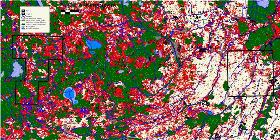
For analysing
the distribution of
biological rich
grass land areas a PCA analysis of 8 ERS-SAR images from two seasons (1997-98)
was made and has been categorised into four classes: Crops (beige), grass /
abandon (red), moist grass/abandon (dark blue) and forest. CORINE land cover
level 1 has been overlaid forest (green) and wetland (light bluish).
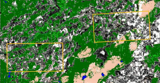
To predict next
years land use intensity, ERS SAR image is used for monitoring cropping in a
rural area in Latvia. White areas indicates ploughed areas or areas to be spring
crops, black areas are seedbeds for winter crop.
Prins (2001)
Methods for indication of biological values and biodiversity in Latvian
farmland - Spatial analysis of land use/cover and landscape in relation to
distribution of birds in the farmland. Technical report: Prepared for the
project: “management of biodiversity in the Latvian farmland – a decision
support system”by Erik Prins Febuary 2001. DANCEE/Ornis Consult Ltd.
Client: DANCEE 1995-2001/
ESA Grant 1999
privacy@prins engineering.com