A change detection
method to monitor the scorched-earth tactics - in Darfur.
This novel use of Landsat
data is a realistic mean to monitor and document the human abuses that have
taken place and is ongoing in Darfur and southern Sudan. Compared to VHR data -
this method is approximately 100 times cheaper and can trace historical changes
- it produces information on villages’ status: recently burnt, unchanged or left
- furthermore, it can quickly reveal what’s going on in the no-go zones of
Darfur or elsewhere.
The
method was developed during
a pilot
study for Amnesty, it
was
based upon change detection between 2003 and 2004 where the satellite images
have been recorded under the same environmental conditions and found that 44% of
the villages in the region covered were burnt. 352 villages were analysed by
comparing the albedo from the two images. 155 of these have strong indications
of the burning, 125 have no significant change, 61 have some change, and seven
of the remaining 11 have some change that can be linked to burning before March
2003. The method has
been verified with an overall accuracy above 98%.
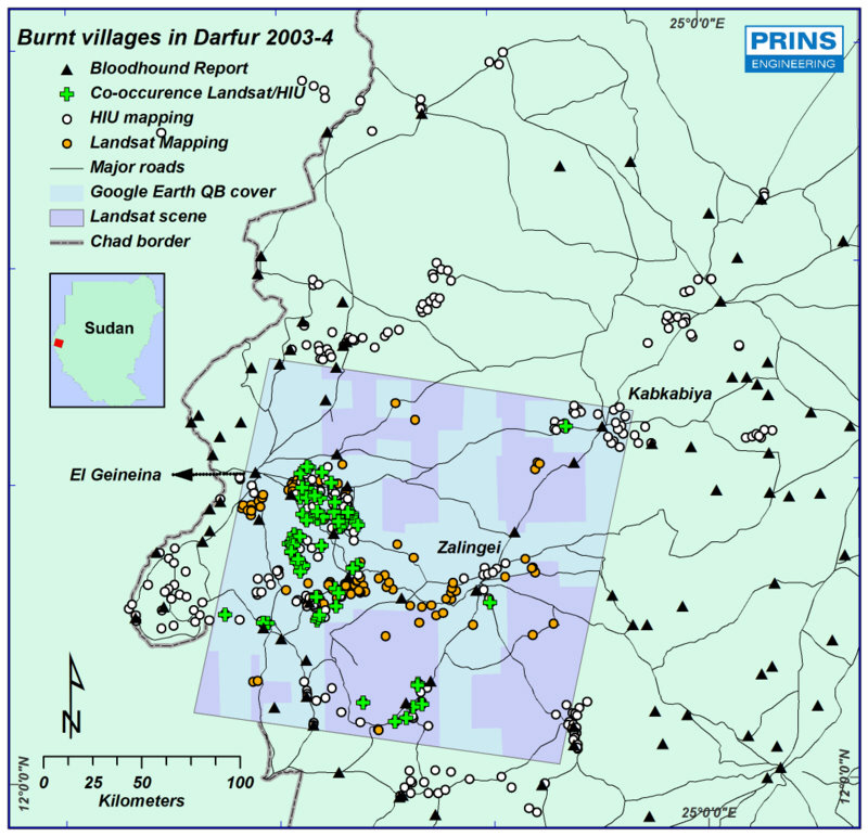
Plotting of burnt villages
from the Landsat study - compared to initial efforts made US HIU by the use of
VHR data.
The study was used for and
had impact on:
·
Main input in
Amnesty Internationals report "Sudan: At the mercy of the killers - destruction
of villages in Darfur" the 2' July 2004.
·
Presented in
UN's Security Council the same week-end, and on the African Unions meeting the
week after.
·
Used by UN
organizations, governments, NGO's and press in several countries.
·
Assisted in
the final pressure that open up for help organizations, international monitoring
and the AU union force.
Awarded the 2005 Nairobi
prize by 90 Danish journalists for the most important news for developing
countries, the method is published by Nature and two times in Danish national
TV.
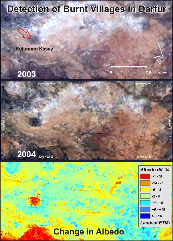
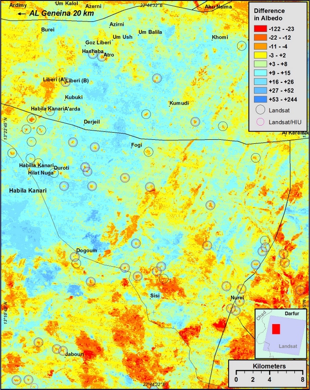
Change detection of albedo
from Landsat data revealed burning of villages. Other areas of change are
related to bush fire scares - these did not ocurred inside the villages.
Change detection of albedo
revealed large scale burning of villages - double rings indicate villages
co-observed by the Landsat /
VHR.
Reference:
Amnesty 2004 Report link: https://www.amnesty.org/en/documents/afr54/072/2004/en/
PRINS, E (2008): Use of low cost
Landsat ETM to spot burnt villages in Darfur, Sudan.
International Journal of Remote Sensing,
(04),
pp. 1207 - 1214.
DOI: 10.1080 / 01431160701730110
Nature 2008:
Satellite can
spot razed villages in Darfur Published online 11 March 2008 | Nature |
doi:10.1038/news.2008.663.
http://www.nature.com/news/2008/080311/full/news.2008.663.html
Ingenøren 2008:
Dansk fotoanalyse afslører afbrændte landsbyer
TV:
Danish Broardcasting
(DR2) Deadline 17 and Science program. Both on
the
developed method
to trace burnt villages in Darfur 22/4-2008.
Satellite can spot razed villages in Darfur; Free imaging data
could rapidly pinpoint some human-rights violations.
March 12, 2008 at 10:40 am | In
Remote Sensing Law Current Events |
by Joanne Irene
Gabrynowicz
Humanitarian
info: on the fantastic work of Erik Prins for Amnesty International on
monitoring burnt villages using remote sensing. Amnesty used his
research as part of their campaigning back in 2004-5, but Erik has just
published an article,
Use of low cost Landsat ETM+ to spot burnt villages in Darfur, Sudan,
in the International Journal of Remote Sensing. The research is right on the
mark.
Client:
Amnesty International / Development Research project by PRINS .
privacy@prins engineering.com
,
Copyright © PRINS, Eng. 2023
About Us |
References
|
Services |
CV's |
Contacts |
Press