MANAGEMENT OF BIODIVERSITY IN SAHEL- A 2012 UNESCO MAB SITE
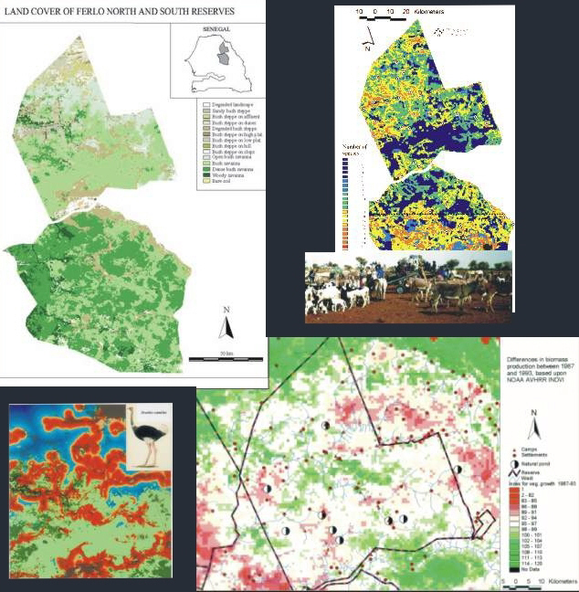
A basic vegetation map was produced from four Landsat scenes, the vegetaion
map was used to model general biodiversity and habitat maps for certain species.
Integration of NOAA AVHRR was used to spot areas with paticular high resource utilization by
linking degraded areas and boreholes with general decreas in biomass production.
In
co-operation with IUCN and Department of National Parks,
Danida has produced a a
management
plan of
the Sahelian fauna reserves of Ferlo
-
11.207 km²,
Senegal. In 2012
Ferlo became an UNESCO MAB site.
A corner
stone in the
project was information derived from
satellites
combined with
faunal
and socio-economic surveys. The build-up decision
support
system
provided information on:
-
Biodiversity, flora and fauna habitats
- Natural
resources and resource utilization
- Annual
update on ongoing desertification and land degradation processes
- Suitable
sites for biodiversity management
We developed
groundbreaking
methods
developed during this project have implication
for
management
of
biodiversity and natural resource utilization in the region.
A biodiversity
model was developed to map number of different birds. The model is based upon
field survey, Landsat TM and NOAA AVHRR data and show the number of different
birds that should be observed on a 3 km transect. The model has a spatial
resolution of 25 m should work in Sahelian Africa.
We further
demonstrated the
use of
differences in
Integrated
Vegetation
Indexes
from NOAA satellites
in combination with other data can
reveal
resource pressure
at different
scale,
especially
for
boreholes and
natural
ponds.
Prins, E (1997):
Remote sensing data for biodiversity management in Sahelian, Africa. EOM
Vol. 6, No. 8, p 18-20.
Prins, E (1997): Natural resources and resource utilization in Ferlo Fauna
reserves, Senegal – A mapping report on natural resources and resource pressure.
Danida/Ornis Consult Ltd. August 1997.
Prins, E.
(1997): Natural
Resources and Resource Utilization in Ferlo Faunal Reserves - a Baseline Mapping
Report on Natural Resources and Resource Utilization. Pp. 37-45 in: Reenberg,
A., Nielsen, I. & Secher-Marcussen, H. (ed.): The Sahel: Natural Resource
Management Projects; Energy Provision; Decentralisation, Empowerment and
Capacity Building. SEREIN Occasional Papers No 5, Institute of Geography,
University of Copenhagen.
Client: Danida 1996-99
privacy@prins engineering.com