INTEGRATED MAPPING ANALYSIS OF THE LOST WORLD
OF BORNEO - MALIAU BASIN
Maliau Basin
or also Maliau Basin Conservation Area, is a region in
Sabah,
Malaysia, which represents a geological
catchment surrounding the Maliau River. Located around the center of Sabah
in the
Sandakan Division, it was designated as a conservation area by the Sabah
Foundation (Yayasan Sabah) in 1981. Later in 1997 the Sabah State Assembly
gazetted the Basin as a Protection Forest Reserve (Class I) with a total
area of 588 square kilometres. The region also features Mount Lotung (1667
metres), Maliau Falls, and Lake Linumunsut. Efforts are underway
(SaBC
2012) to nominate the
area as a
World Heritage Site .
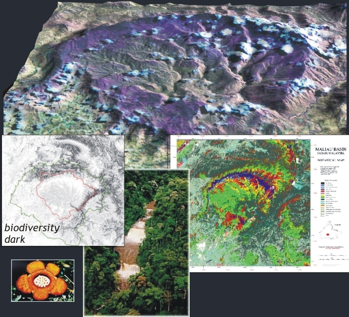
In connection with
a large management project a
large survey of the area was
initiated in 1999 by DANCED in co-operation with Sabah Foundation. For basic
approximation of biological values we produced a botanical forest map by the use
of Landsat data. The classification contained all forest formations and zones -
with record high 12 botanical classes including single species classes.
A Bio and Geo GIS were established for gathering information
on habitats / biodiversity and hydrology. The knowlegde of many species habitats were
very limited, thus, basic information on rare species preferences to
water, botany, altitude etc. were used for producing potential habitat maps.
A predicted general biodiversity map was produced, modeled
from field-studies, Digital Elevation Models, digital botanical map, distance to
water courses and established knowledge on species habitat preference. The
predicted biodiversity map showed that the highest biodiversity was linked to
the remaining lowland rainforest and that the neighboring area Imbak Canyon also
indicated high biodiversity - which later raised the conservation interest of
that area.
The image data further services many other tasks for
establishment of the management plan - such as mapping logging tracks to the
conservation area, overview of remaining forest in the area, delineation of
management zones, input data for hydrological modeling, tracing illegal forest
cutting, and as input for a biological GIS for analyzing habitats of rear
species. The project further encompassed a capacity building component in GIS
and Remote Sensing for management trainees and PhD students.
The results are not only interesting in terms of producing
background information for biodiversity management plans, but has prospects for
REDD/REDD+ as it splits up the vegetation into classes which are commonly
occurring in the mountain rich SE Asia - which eventually have a variation of
biomass of 20-500 m3/ha have
Prins (2002)
Technical Assistance Report No. 21, Mapping and GIS, April 2002, Management of
Maliau Basin Conservation Area, Sabah, Malaysia, Yaysan Sabah/Danced.
PRINS, E and WEBB, C (2003)
Botanical mapping
of rain forest in Borneo by the use of Landsat TM. (draft): Int. J. of Remote
Sensing
Client: DANCED 1999-2002,
Maliau Project Link
privacy@prins engineering.com