ESTABLISHMENT OF A GIS FOR ANALYSING
BIODIVERSITY OF MALIAU BASIN CONSERVATION AREA, BORNEO
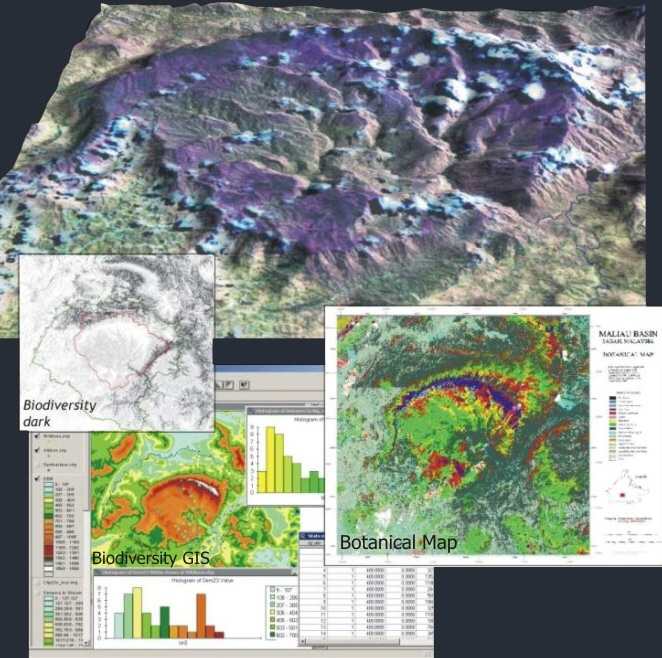
“Maliau Basin Conservation Area” in Sabah Malaysia has until
recently been known as the lost world of Borneo. Within a large management
project for the area we used Landsat images to class out botanical forest types.
The classification contained all forest formations and zones with a record high
12 botanical classes including single species classes.
A Bio and Geo GIS were established for gathering information
on biodiversity and hydrology. The Biodiversity GIS collected basic information
on rare species preferences to water, botany, altitude etc. will can be used for
producing potential habitat maps.
A predicted biodiversity map was produced, modeled from
field-studies, Digital Elevation Models, digital botanical map, distance to
water courses and established knowledge on species habitat preference.
The image data further supported many other management tasks
such as mapping logging tracks to the conservation area, overview of remaining
forest in the area, delineation of management zones, input data for hydrological
modeling, tracing illegal forest cutting, and as input for a biological GIS for
analyzing habitats of rear species. The project further contained a capacity
building component in GIS and Remote Sensing for management trainees and PhD
students.
Prins (2002)
Technical Assistance Report No. 21, Mapping and GIS, April 2002, Management of
Maliau Basin Conservation Area, Sabah, Malaysia, Yaysan Sabah/Danced.
PRINS, E and WEBB, C (2003)
Botanical mapping
of rain forest in Borneo by the use of Landsat TM. (draft): Int. J. of Remote
Sensing
Client: DANCED 1999-2002,
Maliau
Basin
privacy@prins engineering.com