Establishment of DB/GIS
system for management of Peate Swamp Forest
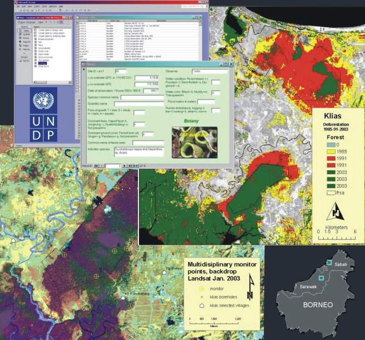
For UNDP/GEF we established an integrated database / GIS for
management of Peate Swamp Forest in Sabah and Sarawak, Malaysia.
For UNDP/GEF we established an integrated database / GIS for
management of Peate Swamp Forest in Sabah and Sarawak, Malaysia.
We established a monitoring system based upon
multi-disciplinary field monitoring points and digital satellite images. The
system collected information on biological indicator species, various
hydrological parameters and human activities. Furthermore, the system used
multi-temporal satellite images to trace deforestation and change in the
surrounding land use. All information could easily be analyzed and give answers
to causes of change within the peat swamp forest.
The consultancy further encompassed preliminary
deforestation analysis by digital change detection, biodiversity analysis based
upon number of different forest classes analysis.
Prins, E
(2003): UNDP-GEF Malaysia
MDAs for the Loagan
Bunut National Park (Sarawak) and the Klias Peninsula (Sabah)
Technical
report on DB/GIS and Monitoring. August 2003
Client: ViSKon/ UNDP/GEF 2003
privacy@prins engineering.com