DANISH FOREST
AND LAND USE / LAND COVER FOR KYOTO REPORTING
The Danish forest have been mapped by satellite - the
project is initiated by ESA and is a part of the ESA / EU program
GMES which will facilitate Earth Observation methods to be harmonized in a
global context for reporting on the state of the environment.
The project has mapped forest and forest changes in Denmark
between 1990 and 2005/6 and the results are used in the Danish CO 2 reporting in
2008-12 on article 3.3. and 3.4.
In addition to the forest assessment from 1990 and 2005 the
project has assessed Land Use and Land Cover classes that are used for Kyoto
reporting: build-up areas, crop, grass and wetlands grasslands and changes in
forest areas.
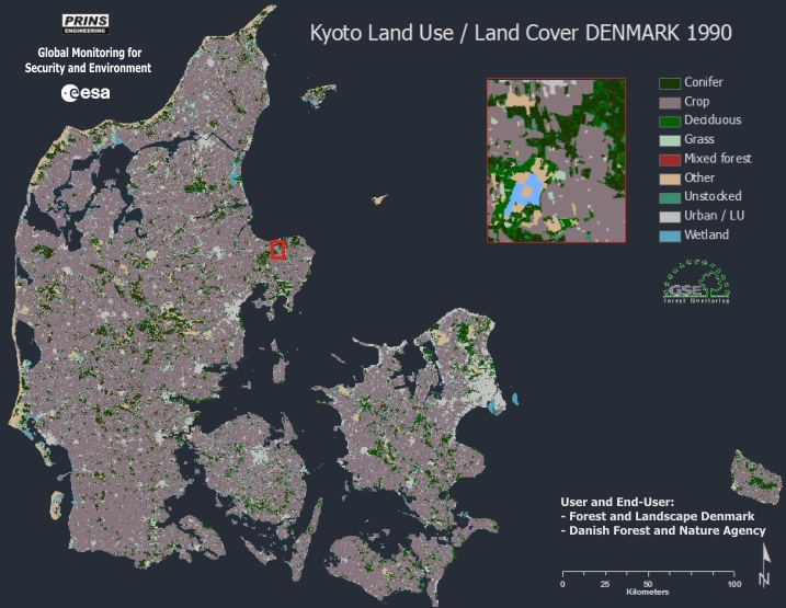
Land Use and Land Cover for Denmark in 1990
Previously, the Danish forest area has been assessed in
various ways and may not be fully comparable. I.e. in the 1990'ties assessments
were based upon questionnaires to forest owners and lately forest area has been
based upon The Danish National Forest Inventory (NFI). The current forest
mapping is based upon UN FAO forest definition (FRA 2000), where forest is
defined as woody vegetation that has a cover of at least 10% in an areas of more
that 0.5 ha and at least 20 m wide, that can exceed 5 m at maturity.
The Danish
forest cover has been assessed to be approximately 13 % in 1990 and 14
% in 2005 - This is significant higher than previous estimates. Especially
for 1990 the previous account was down to 10.9% which can be linked to
difference in methodology and forest definition: Formerly definition was focused
on timber trees, higher grown cover and higher trees. In the same period
agricultural land has decreased from approximately 68% to 66%, while Urban/land
use has increased from approximately 8 to 10%.
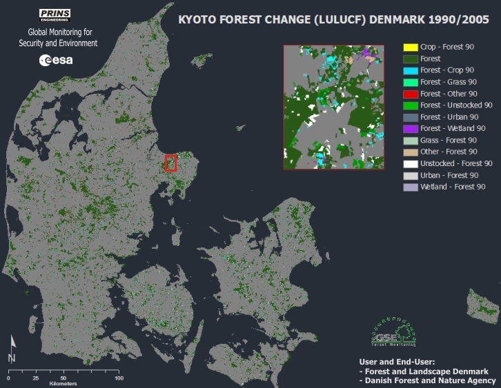
Land Use, Land-Use Change and Forestry (LULUCF) of Denmark -
an account of changes in forest land from 1990 to 2005.
Furthermore, an assessment has been made for
Land use, land-use change and
forestry (LULUCF) which
is defined by the
UN Climate Change Secretariat as "A greenhouse gas inventory sector that covers
emissions and removals of greenhouse gases resulting from direct human-induced
land use, land-use change and forestry activities.
LULUCF has impacts
on the global
carbon cycle and as such these activities can add or remove
carbon dioxide from the atmosphere, contributing to
climate change. LULUCF has been the subject of two major reports by the
Intergovernmental Panel on Climate Change IPCC. Additionally, land use is of
critical importance for
biodiversity. Following IPCC recomandations the Danish ESA project has
mapped various forest types and areas of high forest diversity of old forest
which is directly linked to areas of high biodiversity.
The mapping method used for the Danish Kyoto mapping is
unique, as its uses both high resolution cartographic maps and satellite images
in the mapping. Basically the method take the advance of using land use
information from cartographic maps and combining them with satellite derived
information on cover at an exact date.
The unique mapping method has shown to be very accurate.
Verification has been made by the use of ortho-photo and overall accuracy has
been found to be higher than 97% and forest accuracy approximately 96%. All
products have been fully documented and quality ensured by three external
sources including: GAF AG, ESA and Quali Systems Ltd.
The project is a part of the Forest Service Element (GSE-FM)
of the GMES program in Denmark. The user is Forest & Landscape (FLD) and the end
user is the Danish Forest and Nature Agency (SNS).
The results and methods of the project is used in the Danish
Kyoto/Climate reporting and will be used as an offset to future LULC and LULUCF
assessment in Denmark
Client: ESA 2006-2009 / Forest
and Landscape, Denmark / Danish Forest and Nature Agency
privacy@prins engineering.com