ASSESSMENT OF
AGE, DIVERSITY AND POTENTIAL BIODIVERSITY OF DANISH FOREST
As a part of the ESA / EU program
GMES Service Element for Forest (GSE-FM)
a number of satellite derived Forest indicators have been developed for Denmark.
The
service is intended to support the monitoring and mapping of biological rich
forest areas which comply to the intensions of Council Regulation (EC) No
2152/2003 concerning Monitoring of Forests and Environmental Interactions in the
European Community (Forest Focus); United Nations Convention on Biological
Diversity and Council of Europe Landscape Convention. The service will also be
able to support the Danish part of the NATURA 2000 programme, by helping to
identify some of the potential habitats in the Danish forests.
The service
has implication for
following areas:
1.
Identification of biological rich Danish Forest areas
- servicing the Danish
forest law
2.
Improve reporting obligations for biological rich forest areas
incl.
the Natura 2000
program
3.
Reliability of forest and biodiversity statistics
4.
Forest
statistics used in Denmark
5.
Provides insights into how to best address future biodiversity reporting
commitments
Forest
Indicators:
1.
Forest
Fragmentation - Forest fragmentation index integrated in Danish 1 km grid
2.
Old Mature Forest
- Old Deciduous and Conifer present in Danish 1 km grid
3.
Percentage of Old Deciduous Forest -
Percentage of old deciduous in Danish 1 km grid.
Description:
To facilitate a
national overview three forest indices were produced and integrated into the
Danish 1 x 1 km grid. The input has been the forest layer from the Danish GSE-FM
service for Kyoto reporting representing 2005-6 which hold a geometric accuracy
of < 10 m RMS and a thematic accuracy of > 95%, the forest map has a 0.5 ha
Minimum Mapping Unit (MMU). A more detailed classification of the forest layer
has been made to derived old forest classes of conifer and deciduous. Down
listed forest type and age classes have been used for definition of old forest
classes.
Deciduous (general classes +/- 15 yr)
Age:
Young: new
increment generally under 20 yr
Medium phase: 20
– 90 yr
Old: above 90
Coniferous (general classes +/- 5 yr)
Age:
Young: new
increment generally under 20 yr
Medium phase: 20 –
40 yr
Mature: above 40
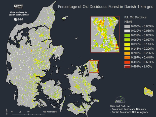
The biological richest forests in Denmark are linked to old
deciduous forest. The map above show areas of highest concentration of old
deciduous forest by percentage of old deciduous forest in the Danish 1 km grid.
Old deciduous
Forest:
Percentage of old deciduous in Danish 1 km grid
was produced
for Denmark from EO data from 2005-7. A reclassification of the forest mask has
done to map old deciduous forest with a 0.5 ha MMU. The product has a geometric
accuracy of < 10 m RMS. A thematic accuracy of 80% +/-
15% for old deciduous forest was required by the user. The realised accuracy was
84.5 %.
The old
deciduous forest index is an important input for assessment of biological rich
forest areas in Denmark which comply to the intensions of Council Regulation
(EC) No 2152/2003 concerning Monitoring of Forests and Environmental
Interactions in the European Community (Forest Focus); United Nations Convention
on Biological Diversity and Council of Europe Landscape Convention. The service
will also be able to substantially support the Danish forest law and parts of
the national Natura2000 programme, by identification of the olds and potentially
biological riches Danish forests.
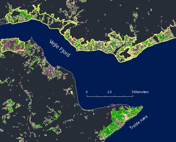
Down listed figure from Vejle Fjord area show an example of
the back-ground data which contain 27 forest classes. Green classes represent
old broadleaved classes. The figure furthermore reveal an extraordinary high
presents of divers old forest in the Trelde næs area which still have to be
fully investigated.
Full detailed example of the satellite derived forest map
which have been used to produce forest indicator maps of Denmark. Green colors
refer to old deciduous forest brown to younger stands, purple colors refer to
conifer where the darkest are the oldest. Yellow polygons are Danish Natura2000
forest habitat areas. The map has a spatial resolution of 25 m.
The production of the old deciduous forest layer is based
upon a method that has been developed for analyzing forest and biodiversity in
Europe’s richest temperate forest - the World Heritage Site Bialowieza forest in Poland
and Belarus. In a wider context, the result of this method can be
correlated with biodiversity and can be used as a single
biodiversity indicator on a European scale. Currently PRINS is investigating the
biodiversity relationship between old forest structures observed from EO data,
forest indexes and in-situ biological indicator data.
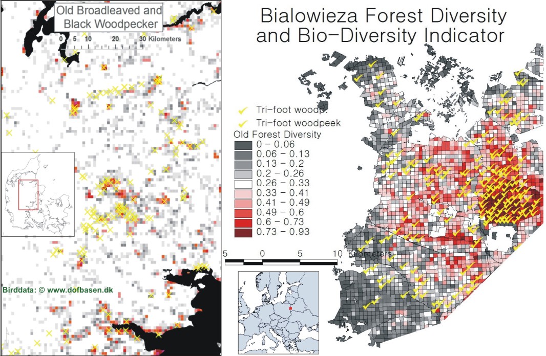
Use of woodpeckers as a forest biodiversity indicator is
well documented. Above figure show the striking co-occurrence between selected
woodpeckers and the PRINS developed EO biodiversity index. (Danish woodpecker
data provided from Birdlife Denmark: www.dofbasen.dk).
Forest
fragmentation
Forest
fragmentation has been calculated from the forest mask of Denmark and is defined
as by the down listed formula (Monmonier, 1974).
A 7 x 7 pixel
window has been used for the calculation and the result has been multiplied by
1000. The mean
scoring have
been integrated into the Danish 1 km grid.
Fragmentation:
F = (n-1)/(c-1)
where
n = number of different classes present in the kernel
c = number of cells considered (7x7 = 49)
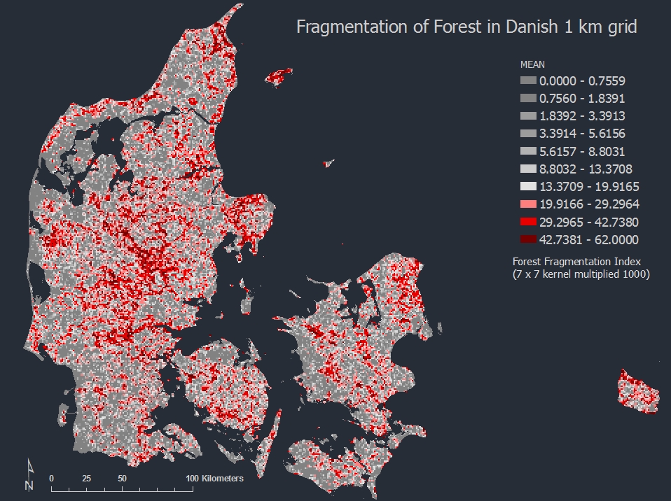
Forest fragmentation of Danish forests
Percentage of Old
Forest
The old forest
classes in Danish 1 km grid was produced for Denmark based on EO data from
2005-7. The forest indicator presents parcels in the Danish 1 km grid where both
old deciduous and old conifer is present.
A reclassification
of the forest mask layer has isolated old deciduous and old conifer forest with
a 0.5 ha MMU. The product has a geometric accuracy of < 10 m RMS. A thematic
accuracy of 80% +/- 15% for old deciduous forest was required by the user. The
realised accuracy was 84.5 %. No direct accuracy assessment was made on old
conifer was made due to insufficient quality reference data. However, indication
of satisfactory accuracy was obtained from NFI data and the old forest classes
indices can be considered as an important contribution for assessment of
biological rich forest areas in Denmark. This comply to the intensions of
Council Regulation (EC) No 2152/2003 concerning Monitoring of Forests and
Environmental Interactions in the European Community (Forest Focus); United
Nations Convention on Biological Diversity and Council of Europe Landscape
Convention. The service will also be able to support the Danish forest law and
parts of the national Natura2000 programme, by identification of the olds and
potentially biological riches Danish forests.
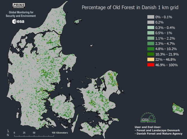
Percentage of Old
Forest classes (both old deciduous and old conifer) in Danish 1 km grid based on
EO data from 2005-7. The forest map shows where the highest concentration of old
forest is located in Denmark.
All the forest diversity products have been fully documented
incl. development of comprehensive metadata and quality ensured by three
external sources including: GAF AG, ESA and Quail Systems Ltd.
Client:
- ESA 2006-2009
- Forest and Landscape, Denmark.
- The Danish Forest and Nature Agency.
privacy@prins engineering.com